Today, I attended a Garrett family reunion south of Richmond. I had a wonderful time chatting with the different family members about their ancestors and their run in with John Wilkes Booth. One relative even brought a picture of the Garrett house that I had not seen before and the handwritten will of one of the Garrett children, which were major pluses. On my way back home, I drove past the site of the old Garrett house in Caroline County. I decided to make a brief stop to check on the place. Then I took out my phone and made this short little video showing the spot in the median where the house once stood:
By the way, for those of you who plan on driving the escape route in the future, the cost to cross the Potomac River Bridge (AKA the Harry Nice Bridge) from Maryland into Virginia is being raised from $4 to $6 effective tomorrow. I need to make sure I put a couple more singles in my center console so I’m not turned away next time.


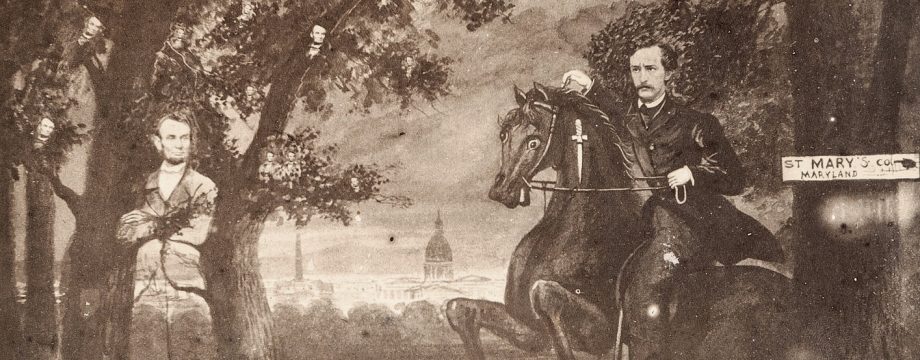
Were you able to take a picture of the Garrett descendant’s photo? Can you show all the known pics of the house on your site? You showed them in your presentation at the SUrratt Conf. in March. Can you make your fonts larger?
Well done!!!
Thanks, great post. I believe someday you will be leading the semi annual Surratt House escape tours. (First you must convince Ms. Verge you are up to the task)
Very nice, Dave. Thanks
Thanks, Joe. As you know, the Garretts are a passion of mine. Every time I’m in Virginia I make it a point to check on the place.
Dave, are there any known pictures of the area surrounding the Garrett Farm before 301 south was put in.? Im curious as to what the terrain looked like. 301 south is several feet below the farm house site. Do you know if that was all level with the ground where the farm house was at one point. If it was level they sure dug down deep to put the highway there whichis interesting of itself.
I am sure that Dave can give a much better answer and probably supply a photo. I recently saw one taken a distance from the house and an outbuilding nearby. Most of the photo was a broad expanse of farm fields — all on flat, level land.
Bill, I know you are a docent at Surratt House. What is now Brandywine Road in front of the museum was once New Cut Road and was put through in 1850. At that time, the road and the house were on the same level. When asphalt came along in Southern Maryland (ca. 1920), the road bed was shaved down and leveled off, and the museum now sits on what appears to be a bank in the front road footage.
Things will change again, because the State Highway Administration plans to increase the length of the right-hand turn lane and plan to take another ten feet off our front lawn. How they will manage a period appropriate (1850-65) retaining wall to protect the National Registry property, I have no idea… So much for preservation.
Thanks Laurie. I had actually noticed that the House seemed to be level with the road on previous drawings and pictures I had seen. I was actually meant to ask you about that previously but had forgotten. You read my
Mind!!
“Used” history teachers have a habit of doing that…!